
Nothing beats a long ribbon of two lane highway, a big sky, and the freedom to pull over whenever a view grabs you. These road trips cut across conservative leaning states where the scenery does the talking and the traffic rarely raises your blood pressure. You will find cattle country that rolls to the horizon, quiet deserts with starry nights, mountain passes that feel like the top of the world, and prairie byways built for unhurried travel. Each route includes practical stops, small towns with friendly cafes, and public lands where you can stretch your legs. Bring a paper map as backup, gas up often, and keep your camera within reach. This is the side of America where the miles fly by and the silence is part of the show.
Big Bend Grand Loop, West Texas

Make Alpine your base and trace a wide loop around Big Bend National Park by linking TX 118, TX 170, and US 385. The drive drops you into the Chisos foothills, then swings to the Rio Grande on FM 170 where the road rises and falls beside sculpted desert bluffs. In Terlingua, grab coffee and browse the ghost town ruins before continuing to Santa Elena Canyon for a short riverside walk. Marathon is a good final stop for fuel and a quiet dinner before the last stretch back to Alpine. Wildlife sightings are common, especially roadrunners and javelina at dawn. Plan one full day for the loop and a second day for a long hike like the Lost Mine Trail.
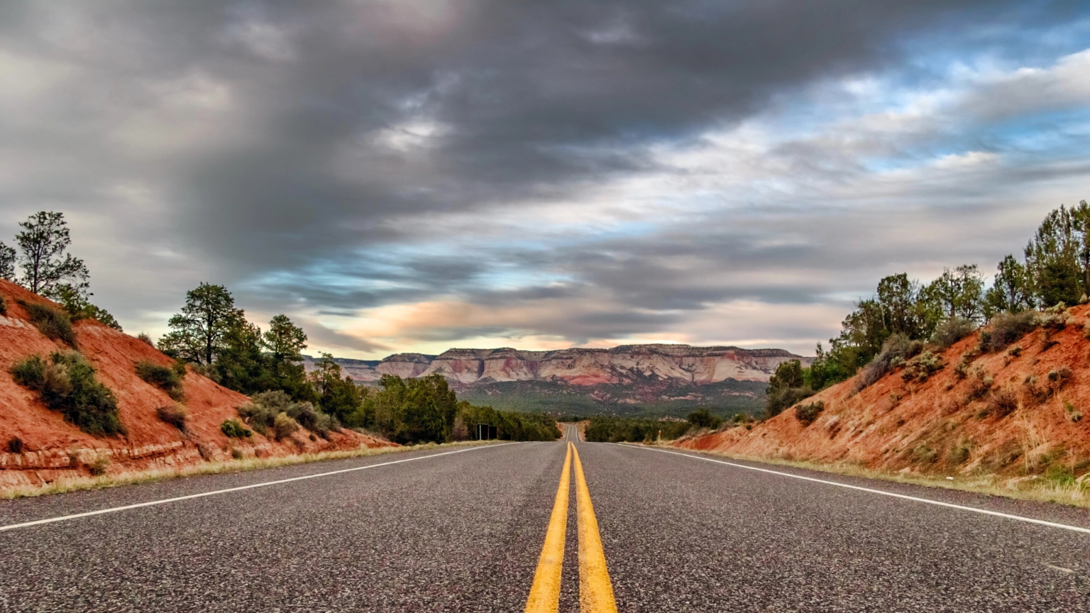
Utah Scenic Byway 12 and the Burr Trail

Start in Bryce Canyon City and follow UT 12 through Red Canyon, over the Paunsaugunt Plateau, and across the slickrock country toward Escalante and Boulder. The pavement weaves among hoodoos, ponderosa, and open mesas, then climbs Hogsback where the views run for miles. In Boulder, turn east on the paved section of the Burr Trail for towering canyon walls and quiet pullouts. Torrey makes an easy overnight with access to Capitol Reef’s orchards and the scenic drive to Capitol Gorge. Expect cooler mornings at higher passes, so pack a layer even in summer. Cell service fades between towns, which makes the wide open feel even bigger.
Wyoming’s Red Desert to Flaming Gorge

From Lander, run US 287 to WY 28 across South Pass where wagon ruts still mark the Oregon Trail. Turn south on WY 372 to cross the Red Desert and watch for wild horses on sage flats that seem to stretch forever. Near Green River, continue to WY 530 for a shoreline ramble along Flaming Gorge Reservoir with big water views and empty pullouts. Manila or Dutch John in Utah offer simple lodging and good diner breakfasts before you loop back north. Afternoon winds can be strong, so secure gear and keep two hands on the wheel. This route delivers thunderheads, sunbursts, and long shadows that photographers love.
Montana’s Hi Line on US 2

Glacier National Park anchors the west end, but the Hi Line’s magic is the space between small towns and rail sidings as you head east. Roll past wheat fields, grain elevators, and big prairie rivers that feel unchanged for generations. Stop in Havre for a stretch and museum time, then continue to Malta and Glasgow where sunsets paint the whole sky. Fort Peck Lake adds shoreline scenery and a quiet place to camp or picnic. Services are spaced out, so keep your tank above half and your cooler stocked. When you reach the North Dakota line, you will understand why locals talk about the sky like it is a landmark.
South Dakota’s Badlands to Black Hills Loop

Base in Rapid City and drive SD 240 through Badlands National Park for striped buttes and easy boardwalk trails. Rejoin I 90 and exit for Wall if you want a classic roadside stop, then swing south to Custer State Park for the Wildlife Loop. Continue on Needles Highway and Iron Mountain Road where stone tunnels frame Mount Rushmore and granite spires line the curves. Overnight in Custer or Hill City where main streets feel built for a slow stroll. Day two can include Spearfish Canyon, a quiet contrast of limestone walls and waterfalls. This loop blends wide open prairies with forested peaks and delivers variety without heavy mileage.
North Dakota Badlands and the Enchanted Highway

Start in Medora and explore Theodore Roosevelt National Park’s South Unit loop for bison, wild horses, and unbroken horizons. Head east on I 94 and drop onto the Enchanted Highway at Exit 72 to follow a quiet county road dotted with oversized metal sculptures. The art feels playful against the prairie and the traffic count is low. Dickinson makes a convenient midpoint for fuel and a burger before you backtrack to Medora or continue toward Bismarck. Summer light lasts late into the evening, which makes sunset stops easy to plan. The combination of solitude and quirky roadside art is classic Great Plains.
Idaho’s Sawtooth and Salmon River Byways

Leave Shoshone on ID 75 and watch volcanic flats give way to jagged peaks as you climb toward Ketchum and the Sun Valley area. Beyond Galena Summit, the view of the Sawtooths appears all at once and sets the tone for the rest of the day. Stanley is a perfect lunch stop on the Salmon River where outfitters swap stories and the water runs cold and clear. Continue north on the Salmon River Scenic Byway to Challis and Salmon with broad valleys and long bends that beg for an unhurried pace. Return south on US 93 over Lost Trail Pass if you want mountain scenery in both directions. Crisp mornings and starry nights make shoulder seasons especially nice.
Nebraska’s Sandhills Journey on NE 2

This two lane byway from Grand Island to Alliance is one of the best prairie drives in the country. Grass covered dunes roll in every direction and the road feels like a ribbon laid gently on the land. Stop in Broken Bow for coffee, then in Thedford for a walk at the Nebraska National Forest bison overlook. In Alliance, visit Carhenge for a fun photo before dinner on Main Street. Birders should plan spring or fall for migrating cranes and raptors over wide fields. The calm of this route is the point, so lean into the quiet and the long views.
Kansas Flint Hills on K 177

The Flint Hills hold the last large piece of North American tallgrass, and K 177 cuts right through the heart of it. Start in Council Grove, a handsome town with Santa Fe Trail history, then cruise south to Cottonwood Falls and the courthouse square. Stop at the Tallgrass Prairie National Preserve for the scenic ranch road or a short trail through waving bluestem. Strong City and Matfield Green add art studios and tiny cafes that welcome road trippers. Spring brings fresh green and wildflowers while late summer turns the hills golden and soft. This is a day that resets your pace and your mood.
Oklahoma Osage and the Tallgrass Loop with a Route 66 Detour

Begin in Tulsa with a quick museum visit, then head north to Osage Hills State Park for oak woods and quiet campgrounds. Continue to the Tallgrass Prairie Preserve where bison graze against an open sky and gravel roads wander for miles. Pawhuska works for lunch and a downtown stroll before you push west for a short nostalgia run on historic Route 66 near Bridgeport. Return to Tulsa through rolling ranchlands as the sun drops behind fence lines. Watch your fuel if you explore side roads since stations can be spaced widely. This loop delivers prairie, small towns, and a taste of Mother Road charm.
Alaska Parks Highway and the Denali Highway

From Anchorage, take the Parks Highway through the Matanuska Susitna Valley toward Denali’s broad shoulders. Turn east onto the Denali Highway at Cantwell for a long stretch of mostly gravel with mountain vistas in every direction. Pullouts double as trailheads and photo spots with tundra underfoot and silence that feels complete. Late June through early September offers the best conditions, though weather always calls the shots. Stay in cabins at Alpine Lodge or camp at roadside BLM sites and wake to alpenglow on distant peaks. The vastness on this route redefines the idea of an open road.
Tennessee and Mississippi on the Natchez Trace Parkway
Pick up the Parkway near Franklin, Tennessee, and settle into a steady pace on a two lane road with no billboards and a canopy of trees. Stop at Leipers Fork for coffee, then continue to the Duck River overlook and short nature walks that break up the miles. Cross into Mississippi and plan a picnic at the Pharr Mounds area where wide fields meet quiet woods. Tupelo makes an easy overnight with classic Southern cooking and an unhurried downtown. The Parkway speed limit keeps you relaxed and the spacing of pullouts suits easy planning. By the time you exit toward Jackson, your shoulders will have dropped a notch.
Arkansas Ozarks and the Buffalo National River

Begin in Jasper and drive AR 74 and AR 7 for balcony views over deep hollows and ridgelines. Boxley Valley often shows elk at dawn and dusk, which makes an early start worth the alarm. Hike to Hawksbill Crag or Lost Valley for short rewards and then continue to Ponca and Steel Creek where the Buffalo runs clear under limestone cliffs. Push east toward Tyler Bend and St Joe for a picnic and a swim on warm days. Mountain towns along the route offer pie, strong coffee, and friendly advice. The curves are steady but never rushed, which fits the slow feel of the Ozarks.
Louisiana’s Creole Nature Trail All American Road

Set out from Lake Charles and loop through Cameron Parish on a coastal byway built for birding, marsh views, and big horizons. Boardwalks cross wetlands where you can spot herons and gators, and wide beaches allow quiet walks with no high rise backdrop. Sabine National Wildlife Refuge offers an easy wildlife drive and photo stops with long lines to the horizon. Cameron and Holly Beach provide simple services and a relaxed pace that invites lingering. Watch tides and check ferry status across the Calcasieu Ship Channel before you go. Sunsets here wash the sky with color that reflects in every shallow pool.
Mississippi Delta on US 61

Roll south from Clarksdale on the Great River Road and let the fields and straightaways set your tempo. Blues history dots the route with roadside markers, juke joints, and small museums that reward a quick stop. Greenville and Leland offer diners where locals swap crop talk and river stories. Detour to the levee for big river views and a sense of the land that shaped the music. Spring and fall bring mild temperatures and soft light, perfect for unhurried photography. This is a drive about mood as much as miles, and it delivers both in full.
This article was written by Hunter and edited with AI Assistance